I am always asked how to present the design on satellite imagery. Trimble Business Center has a native export into this Earth browser.
How to export data into Google Earth ?
Once design is done and checked. Just head into your Home ribbon and the Google Earth button. Under your command pane select the items you want to export. Next are able to to set your Google Offsets [this is not necessary if you have a published coordinate system and/or calibration]. Choose your Altitude mode “Clamp to Ground” (all points are located at ground level) or “Absolute” (all point are displayed at their correct elevations based on the offset value entered in the Elevation box). Lastly hit apply and see how your entities are flying onto Google Earth.
Do I need Google Earth installed on my computer ?
Simple and quick answer is YES, how ever I recommend to install Google Earth Pro which is now free. This will give you few free features like go back in time and scroll through previous Google Earth images. To find out how to get and install Google Earth Pro please check out the video below.
What is KML and KMZ ?
KML is a file format used to display geo data in Earth browsers. KML file structure is based on xml standard ad used tag-based elements with embodied elements and attributes. The most popular Earth browser is Google Earth which has basically invented the format. KMZ is the KML in zipped format with all the attributes of KML.
How to create KML and KMZ ?
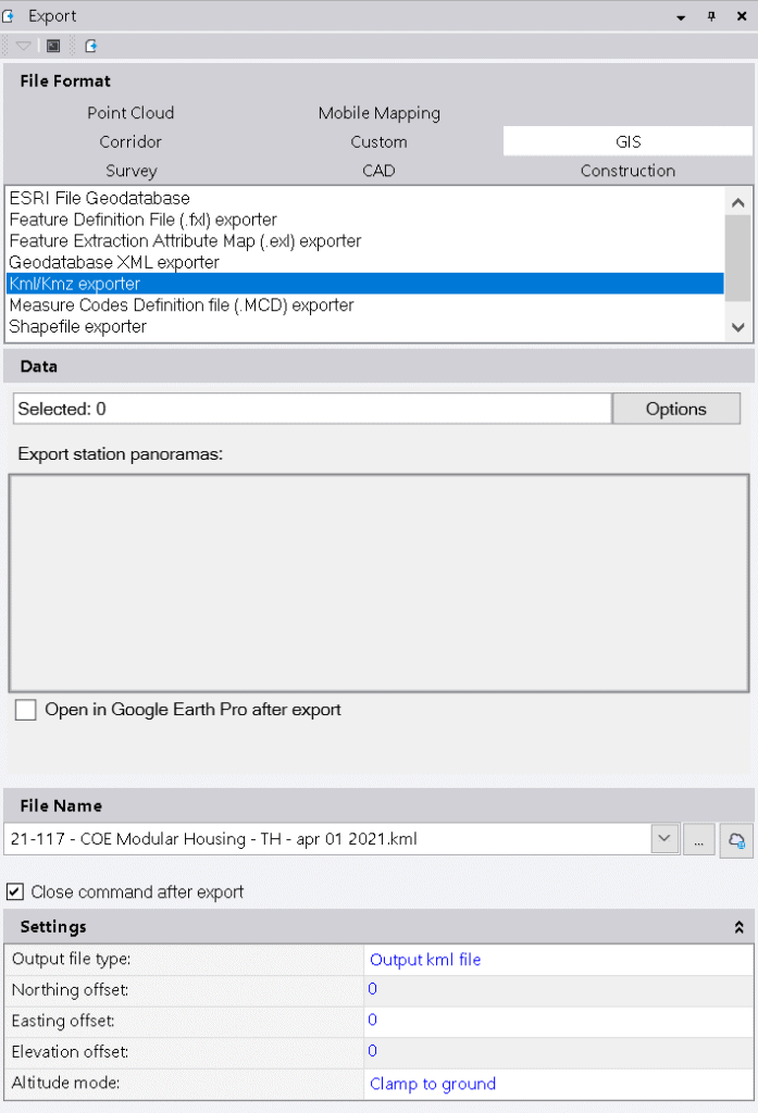
Great news Trimble Business Center has an exporter for that. Just head to your Home ribbon and hit Export button. Once in export command pane and hit GIS tab. Under GIS tab select the KML /KMZ exporter. Select the data you want to export. If you are using panoramas you can export them so you can view them in Google Earth. You can click the check box to open Google Earth right after you export your file. Choose where and name of the file. Reminder of setting are the same as exporting direly to Google Earth. Once exported file can be shared and viewed on any device where Google Earth is installed.
Can I bring Google Earth image into Trimble Business Center ?
The short answer is YES. The procedure is outlined in the following video for ease of explanation. It is as simple as exporting few entities [preferably points] into Google Earth. Next step is to save Google Earth image at the highest most possible resolution onto your computer. Than just drag and drop the image into your project and georeference it. And that is it you have an Google Earth image as you background map in Trimble Business Center.
YouTube video on how to use Google Earth image as background map in TBC:
Join us at our linked in group for Trimble Business Center: https://www.linkedin.com/groups/4468209/
Recent Posts
Explore the future of precision with Galileo HAS, revolutionizing global positioning for autonomous vehicles, agriculture, and beyond.
🚀 Exciting Update: TBC 2023.11 Patch Release! 🚀We're thrilled to announce the latest patch for TBC, packed with crucial bug fixes and enhancements that promise to elevate your...


